


 My blog
  Support me on Tipeee!


Sunday30October
Temuco
Having left the previous evening at 10:30 PM, we arrive in Temuco around 6:30 AM. A night of travel in the "semi-cama" bus where you can almost lie down to sleep. We then take a taxi to the airport, not to catch a plane but to pick up our rental car that we had reserved from France.

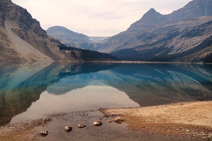
Pucón
We reach Pucón, about a hundred kilometers from Temuco. This small resort town is located on the shores of Lake Villarrica and the volcano of the same name...
From the town's main street, the snow-capped volcano stands out against the blue sky it ordered for our first day! We'll have to enjoy it because it won't last... And while temperatures are mild today, we still had to pack away our shorts and t-shirts because we lost at least 10 or 15 degrees on our descent south... We'll get our summer clothes back in 2 weeks when we reach Easter Island! 

And we don't lose good habits... Chicken and fries!

Ojos del Caburgua
For this afternoon, short walks in the surroundings of Pucón. Here, about ten kilometers away, in the "eyes of Caburgua" (los ojos del Caburgua), a small point of transparent blue water in the middle of the woods where various streams from Lake Caburgua flow.


The transparent water where silver coins thrown by superstitious passers-by scatter across the bottom of this small lagoon.

Playa Grande
Facing Lake Caburgua, the "Grande" beach where you can park your car directly at the water's edge...


Los Tres Saltos de Huepil
Change of location for a beautiful panoramic view of the region and its mountainous terrain, and especially (in the background) its Villarrica volcano.

Zoom on the volcano.

The volcano is active. It's even possible to climb to the crater to see potential lava "spits"... But alas, we don't know it yet, but the weather will be very bad for the next few days and we will skip it...

We can make out the smoke escaping from the crater...


A Southern Lapwing (Vanellus chilensis) also came to enjoy the view...

The name of the place (los tres saltos) comes from the three waterfalls that follow one another along the steep mountain.


Monday31October
Geometric Hot Springs
There you have it! As we feared, for this new day, the weather has turned bad! So we take advantage of this mishap to go enjoy the hot springs of Termas Geométricas! At an altitude of 1000 meters, these hot springs are nestled in a 450-meter long gorge south of the Villarrica volcano, benefiting from waters heated by the subsoil near the magma...

The rain is therefore present, but it doesn't hinder swimming in the various pools available all along the small canyon. Ranging from 35 to 40 degrees, the baths are very pleasant, especially since it's cold outside!

And then little by little, as the cold intensified, the rain turned into snow! To everyone's delight, the landscape transformed before our eyes, changing from green to a white blanket...


And to go from pool to pool, you have to cross icy walkways, and when you're barefoot like us, you do it at a run! And watch out for slips!...


At the end of the walkways, a waterfall adds an exotic touch to the already superb scenery. But no time to linger because the snow isn't letting up!


Well, that's it for this day of relaxation. We hit the road again in the snow, but fortunately the path remains passable and we quickly find a milder climate in the valley.

Tuesday1November
Another day with still uncertain weather... We try to visit the volcanic caves on the slope of the Villarrica volcano, but that was without counting on the snow, and despite our all-terrain vehicle, we get stuck just like the yellow van ahead of us... Oh well, we turn back and will try our luck later!


Back in Pucón and for now, all is well! The town has set up a traffic light system to inform residents of the volcano's danger level! 

Volcanic Caves
Second attempt to reach the volcanic caves and this time it's a success, our car was able to pass the snowy paths without any problems! And given the weather and the time of year, here we are, helmeted and alone with the guide, to venture into the volcanic tunnel!

This cave was formed by lava flows from Villarrica, whose crater is located 5 kilometers away.

The interior of the cave. Only 1500 years ago, a lava flow solidified on the surface, allowing the rest to flow beneath it, thus forming the cave.


Some minerals have transformed the ceiling of the vault into a true chocolate trompe l'oeil!


We exit through the same place. There is only one passage to access the cave.

The ground above the cave.

A little further on, a suspension bridge spans a gorge that reveals the different strata, an image of the millions of years of history that preceded us...


In the distance, the small hut near the volcanic cave.

Here we are on the other side of the bridge, in a coniferous forest whose bare treetops seem to indicate that fires have occurred here.


A little artistic break with this snowman passing in front of the volcano facing him... doubt.gif

In the distance, the clouds surreptitiously reveal the Villarrica ski lifts... Yes! You can ski on the volcano's slope!!!

Precisely, we get back in the car and head to the Pucón ski resort.


Ski lifts, chairlifts, gondolas, everything is there for the greatest pleasure of snow sports enthusiasts!

Along the roads climbing the slopes of the volcano, many "notros" trees have bloomed with their red flowers (Embothrium coccineum).


Salto el León
After the northern slope of the volcano, we head east, about twenty kilometers as the crow flies but fifty kilometers by road. Here we are in front of a superb and impressive waterfall, Salto El León.


90 meters of water fall before us, but alas, it's difficult for us to fully enjoy it because torrents of water are also falling on our heads with the wind and rain! In any case, night will soon fall, so it's time for us to return to our cabin in Pucón!


Wednesday2November
Hike Santuario el Cañi
A window opens to attempt a day hike. The weather forecast seems to predict mild weather, so we decide to dedicate this day to the "Santuario El Cañi" site.
This path crosses a protected natural reserve and leads to the summit of the mountain where we are promised a superb panoramic view of the surrounding volcanoes.

The walk begins with some animals. Let's enjoy them because we will encounter very few along the path! First, a black-faced ibis (Theristicus melanopis). Before the intense heat of the north of the country arrives, this pelecaniform has undoubtedly recently migrated to leave the too-hot north of the country and thus spend the summer in these cooler latitudes.


These sheep have surely traveled far fewer kilometers to go from winter to spring...


The first two kilometers are quite steep but it gets better afterwards. We will have to cover 8 kilometers and 1000 meters of elevation gain to reach the summit located at 1550 meters above sea level. The hike is composed of 9 stages, each marked by clearly visible wooden symbols. Here is the first, the Kutralko (agua de fuego, fire water...).


Followed by the second called Mamüll and the third, the Aserradero refuge.


The view from the refuge with Lake Caburgua in the background.


The interior of the refuge with the central fireplace.


We hit the road again and the first traces of snow appear. The guide who greets and advises hikers at the beginning of the trail told us there wasn't much snow up to the summit... Hmmm... we'll see about that... doubt.gif


Close-up of a Berberis darwinii (Darwin's barberry).


Lichens hang from the branches forming "old man's beards", the Spanish name (barba de viejo) given to these organisms colonizing trees. Their presence is also a very good indicator of clean air.


The stages "Silencio" and "Laguna las totoras".


This is where the araucaria zone begins, with many trees here. They also give their name to the region.

On the other side of the lake, the snow-covered araucarias.

Old man's beard and Darwin's barberry.


It's 1:00 PM and we arrive at the 6th stage called "Pewen". There are 2 more stages to pass before reaching the summit located 1500 meters from here. We've been walking for a little over 3 hours and the ground is now completely covered in snow, contrary to what the guide told us.
Then we cross paths with a Frenchman who is turning back. He tells us that up there, there's too much snow to find the path and that, incidentally, his feet are frozen and completely soaked... Well, it doesn't look very good for reaching our objective! But never mind, let's keep going as long as it's possible!


15 minutes later we arrive at the 7th and 8th stages facing this small lake (Laguna Negra). Despite the cold, we take advantage of the place for a quick picnic, we've been walking for 3h30! And we need to regain our strength because the hardest part is yet to come!

A grey-headed goose (Chloephaga poliocephala) splashes around in what will be its summer resort...


We are refreshed and back on the road. There are only 800 meters left to cover, but the elevation gain is significant and the snow depth is considerable, hiding the path... Especially since 2 other hikers confirm that they are giving up, having been unable to find access to the summit... Yes, but they didn't have a map of the area on their smartphone or the GPS that goes with it! So we set off, determined to succeed in this little epic...

Pause before the ascent...
And indeed, our walk is difficult. We advance blindly, scrupulously following the GPS indications where the path is clearly marked... Our socks are soaked and our feet numb with cold, but we keep going anyway. Suddenly, a Chilean hiker appears and falls into our wake. So here we are, three of us, to reach the grail...

There! We made it! It took us an hour to climb these 800 meters... But now, here we are proudly facing the last symbol, the Melidekiñ viewpoint!

Alas, but we expected it a little, the panorama is well obscured by clouds, and where 4 volcanoes should have stood around us, only a thick gray and humid fog can be distinguished... Too bad, it will be for another time! Or not... 


In any case, here, the one who reigns supreme on its summit is indeed the Chilean araucaria (Araucaria araucana). It is the national tree of the country and has been an endangered species since 2013.

The clearest view we would get. Not enough to see the volcanoes...
A little snowman as a gift for the viewpoint... Now we have to go back down into the valley. And if it took us 5 hours to reach the summit, it will take us 3 to descend... Phew, big day!


Back in Pucón in our cabaña where a good night's rest awaits us!

Thursday3November
Lago Caburgua - Playa Blanca
The weather is still not on our side for our last day in the region. We still take the car to discover some interesting spots in the area. We start with the large beach of Lake Caburgua in the town of the same name.


A chimango caracara (Milvago chimango) also enjoys the deserted beach.


Two great grebes (Podiceps major). This bird is rarely in the air. It builds its nest on aquatic vegetation.


A southern lapwing (Vanellus chilensis).

On the side of the beach developed for residents.

Lunch at the small restaurant "Los Castillos" near Caburgua. We are the only customers and the charming little grandmother who runs the restaurant is very attentive to us. She offers us the daily menu, that will be perfect!


Ojos del Caburgua
Back to the small lagoon but this time on the other side.


Los Pozones Hot Springs
And to end the stay, what better than a relaxation in the warm waters of the hot springs. Here we are at "Los Pozones" which does not have the charm and beauty of the Geometricas site but it will do just fine!

The pools border the Liucura River which flows into Lake Caburgua.


Friday4November
Pucón
In case of a Villarrica eruption, follow the green arrows to reach the safety zones... huh.gif

Two "Mapuche" indigenous people (the first Amerindian inhabitants before the Spanish colonization) welcome the passerby in this small port built on the shore of Lake Villarrica.


A red-gartered coot (Fulica armillata).

And always the usual evacuation signs in case of an eruption.


The small mountains around the city.

Temuco
Return to Temuco airport, not to catch a flight but to return our rental car. We then take a shuttle that takes us to Temuco bus station, from where we will depart by bus south to reach another region, Llanquihue, and another volcano, Osorno.

The "JAC" bus station in Temuco.

Latest comments
On Guatemala 2018
Le 25 Novembre 2024
Significado de este mural
On Chile 2016
Le 15 Septembre 2024
Rrrrrr
On Egypt 2003
Le 1er Avril 2023
Et oui c'est bien nous aux pieds de ce Colosse !
Le 1er Avril 2023
Bien petits aux pieds de ce Colosse !
On Namibia 2014
Le 3 Août 2021
very good indeed